Aids to navigation
Aids to navigation are special
structures like lighthouses, lightships, beacons, buoys, etc that are used to
enhance safety by providing more opportunities to obtain LOPs.
These lights and marks are prescribed across the world by the
International Association of Lighthouse Authorities (IALA). In 1977 this
IALA endorsed two maritime buoyage systems putting
an end to the 30 odd systems existing at that time. Region A -
IALA A covers all of Europe and most of the rest of
the world, whereas region B - IALA B covers only the
Americas, Japan, the Philippines and Korea. Fortunately, the differences between
these two systems are few. The most striking difference is the
direction of buoyage.
All marks within the IALA system are distinguished by:
-
Shape
-
Colour
-
Topmark
-
Light
Light identification
During daytime, the identification of aids to navigation is
accomplished by observing: location, shape, colour scheme,
auxiliary features (sound signals, RACON,
RC,
etc) or markings (name, number, etc).
During the night, we use the features of the aid to navigation's
light to both identify it and ascertain its purpose.
There are three features to describe the light:
-
Colour: Either white, red, green
or yellow. If no colour is stated in the chart, default is white.
-
Period: The time in seconds
needed for one complete cycle of changes.
 The
arrow indicates the 10 second period of this flashing light “Fl(3) 10s”.
The
arrow indicates the 10 second period of this flashing light “Fl(3) 10s”.
-
Phase characteristic: The
particular pattern of changes within one complete cycle (hence, within one
period). Below are the most common types:
-
Fixed F
 This
light shines with an unblinking and steady intensity and is always on. In
this example a yellow fixed light is shown.
This
light shines with an unblinking and steady intensity and is always on. In
this example a yellow fixed light is shown.
-
Flashing Fl:
 The
duration of the light is always less than the duration of the darkness. The
frequency does not exceed 30 times per minute.
The
duration of the light is always less than the duration of the darkness. The
frequency does not exceed 30 times per minute.
-
Quick Flashing Q:
 Again,
the duration of quick flash is less than the darkness. The frequency is at
least 60 times per minute.
Again,
the duration of quick flash is less than the darkness. The frequency is at
least 60 times per minute.
-
Very Quick Flashing VQ:
 Also
here, the duration of very quick flash is less than the darkness. The
frequency is at least 100 times per minute.
Also
here, the duration of very quick flash is less than the darkness. The
frequency is at least 100 times per minute.
-
Interrupted Quick Flashing
IQ:
 Like
Quick Flashing with one moment of darkness in one period.
Like
Quick Flashing with one moment of darkness in one period.
-
Isophase Iso:
 This
Light has equal duration between light and darkness. A period consists of
both a light and a dark interval. Also called Equal Interval (E Int).
This
Light has equal duration between light and darkness. A period consists of
both a light and a dark interval. Also called Equal Interval (E Int).
-
Group Flashing Gp Fl(x+x):
 This
is actually a combination of two patterns in one period. In this example the
first 2 flashes followed by the pattern of 3 flashes result in: Gp Fl(2+3).
This
is actually a combination of two patterns in one period. In this example the
first 2 flashes followed by the pattern of 3 flashes result in: Gp Fl(2+3).
-
Occulting Occ:
 Occulting
is the opposite of flashing, the light is more on then off.
Occulting
is the opposite of flashing, the light is more on then off.
-
Alternating AL:
 An
alternating light changes colour. This special purpose light is typically
used for special applications requiring the exercise of great caution. In
this example ALT.WG is shown, alternating between green and white.
An
alternating light changes colour. This special purpose light is typically
used for special applications requiring the exercise of great caution. In
this example ALT.WG is shown, alternating between green and white.
-
Morse U Mo (U):
 This
light shows two flashes and a longflash, which is equivalent to the letter
“U” in Morse code.
This
light shows two flashes and a longflash, which is equivalent to the letter
“U” in Morse code.
-
Long-Flashing LFl:
 This
light has one long flash in a period. A long flash is at least 2 seconds
long.
This
light has one long flash in a period. A long flash is at least 2 seconds
long.
Let's look at some examples using colour, period and phase
characteristics. The arrows mark the periods:
-
 Fl
(4) 8s
Fl
(4) 8s
-
 Oc
(2+3) 10s
Oc
(2+3) 10s
-
 Iso
G 4s
Iso
G 4s
All lighted aids to navigation are either
major or minor lights,
where major lights are used for key navigational points along sea-coasts,
channels and harbour and river entrances. These lights are normally placed in
lightships, lighthouses and other permanently installed structures, providing
both high intensity and high reliability of the lights. Major lights are then
subdivided in primary lights (very strong, long
range lights used for the purpose of making landfalls or coastal passages) and
secondary lights (shorter range lights found for
example at harbour and river entrances). Important details of (especially)
primary lights can be found in a reference called the
Light List where information (about pedestals etc.) can be found which is
not included in the chart.
Minor lights on the other hand are likely to be found within harbours, along
channels and rivers. These have a low to moderate intensity and sometimes mark
isolated dangers.
Five types of navigation buoys
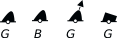
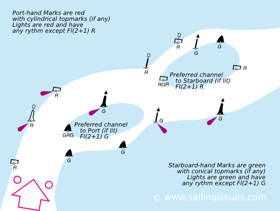
Lateral Buoys and Marks
The location of lateral buoys defines the borders of channels
and indicates the direction. Under IALA A red buoys mark the port side of the
channel when returning from sea, whereas under IALA B green buoys mark the port
side of the channel when sailing towards land. Red buoys have even numbers and
red lights; green buoys have odd numbers and green lights. Lateral lights can
have any calm phase characteristic except FL (2+1).
 Generally, when two channels meet, one will be designated the preferred channel
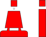
(i.e. most important channel). The buoy depicted on the right indicates the
preferred channel to starboard
Generally, when two channels meet, one will be designated the preferred channel
(i.e. most important channel). The buoy depicted on the right indicates the
preferred channel to starboard under IALA A. The light phase characteristic is R FL (2+1):

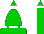
 The
buoy depicted on the left indicates the preferred channel to port
under IALA A. These buoys are marked with the names and numbers of both
channels. The light phase characteristic is G FL (2+1):
The
buoy depicted on the left indicates the preferred channel to port
under IALA A. These buoys are marked with the names and numbers of both
channels. The light phase characteristic is G FL (2+1):

For an example of lateral buoys used to mark a (preferred) channel, see
direction of buoyage below.
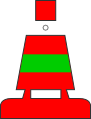
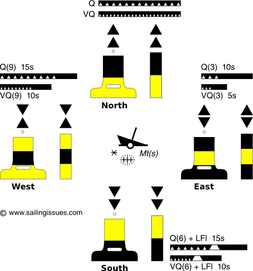
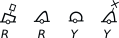
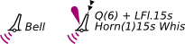
Cardinal Buoys
The four cardinal buoys indicate the safe side of a danger with
an approximate bearing. For example, the West cardinal buoy has safe water on
its West and the danger on its East side. Notice the “clockwise” resemblance of
the light phase characteristics. The top marks consist of two black triangles
placed in accordance with the black/yellow scheme of the buoy. When a new
obstacle (not yet shown on charts) needs to be marked, two cardinal buoys
- for instance a South buoy and an East buoy - will be used to indicate this
“uncharted” danger. The cardinal system is identical in both the IALA A and IALA
B buoyage systems.
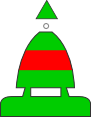
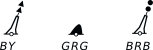
Marks indicating isolated dangers
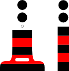 This
type of buoy indicates the position of an isolated danger, contrary to cardinal
buoys which indicate a direction away from the danger. Body: black with red
horizontal band(s); Topmark: 2 black spheres. The light (when present) consists
of a white flash: Fl(2).
This
type of buoy indicates the position of an isolated danger, contrary to cardinal
buoys which indicate a direction away from the danger. Body: black with red
horizontal band(s); Topmark: 2 black spheres. The light (when present) consists
of a white flash: Fl(2).

Marks indicating safe water
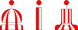 Notice that whereas most horizontal striping spells “danger”, this safe water
buoy is vertically striped. These marks are for example seaward of all other
buoys (lateral and cardinal) and can be used to make landfall. Body: red and
white vertical stripes; Topmark (if any): single red sphere. Lights are
typically calm and white: Morse A, Iso, Occ or LFl 10s.
Notice that whereas most horizontal striping spells “danger”, this safe water
buoy is vertically striped. These marks are for example seaward of all other
buoys (lateral and cardinal) and can be used to make landfall. Body: red and
white vertical stripes; Topmark (if any): single red sphere. Lights are
typically calm and white: Morse A, Iso, Occ or LFl 10s.
Special Buoys and Marks
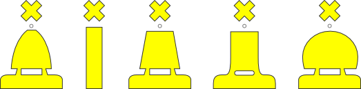
I saved these buoys for last since they have not an actual navigation purpose.
Most of the time these yellow buoys indicate pipelines or areas used for special
purposes. I have drawn the five official IALA shapes, from left to right:
conical, spar, cylindrical, pillar and spherical.
Chart symbols
The seafaring nations of the world - members of the
International Hydrographic Organization - agreed in 1982 on an universal
set of chart symbols, abbreviations, colours, etc to be used in the nautical
chart, in order to obtain uniformity.
On regular charts a white, red, yellow or green lights will be
indicated by
 ,
and on GPS displays and modern multi-coloured charts in specific colours:
,
and on GPS displays and modern multi-coloured charts in specific colours:
 ,
with the yellow coloured lobe indicating a white light.
,
with the yellow coloured lobe indicating a white light.
The precise position of a chart symbol is its center, or is indicated with a
line and circle
 ,
the “position circle”.
,
the “position circle”.
Two distinct types of sea mark are drawn
differently in the chart:
-
beacons - fixed to the seabed;
drawn upright;
-
buoys - consisting of a floating
object that is usually anchored to a specific location on the sea floor;
drawn at an oblique angle and with oblique numbering, descriptions of
colours and light characteristics.
|
 |
Major floating light (light-vessel, major light-float,
LANBY) |
|
 |
Light-vessel |
|
 |
Major light; minor light |
|
 |
Green or black buoys (symbols filled black): G =
Green ; B = Black |
|
 |
Green or black beacon (symbol filled black). Note the
upright G, instead of an oblique G |
|
 |
Single coloured buoys other than green and black: Y
= Yellow ; R = Red |
|
 |
Coloured beacon other than green and black, the symbol
is again filled black so only the shape of the topmark is of
navigational significance. |
|
 |
Multiple colours in horizontal bands, the colour
sequence is from top to bottom |
|
 |
Multiple colours in vertical or diagonal stripes, the
darker colour is given first. W = White |
|
 |
Spar buoy (here a safe water mark) |
|
 |
Lighted marks on multi-coloured charts, GPS displays and
chart plotters.
|
|
 |
Lighted red beacon on standard charts. |
|
 |
Red beacon and green buoy with topmark, colour, radar
reflector and designation. Red buoys and marks are given even numbers,
green buoys and marks are given odd numbers. |
|
 |
Wave-actuated bell buoy to the left, and to the right a
Light buoy, with a horn giving a single blast every 15 seconds, in
conjunction with a wave-actuated whistle. Other sounds include “Gong”,
“Siren”, “Diaphone” (Dia).
The fog signal symbol
 may be omitted when a description of the signal is given.
 |
|
 |
Leading beacons
- Leading line (firm line is the track to be followed) |
|
 |
Leading lights
(≠ : any two objects in line under each other). Bearing given in degrees
and minutes. The lights are synchronized. The red light has a shorter
nominal range (the distance from which the light can be seen): 10
nautical miles. |
|
 |
All-round light with obscured sector |
|
 |
Sector light on multi-coloured charts.
The elevation is 21 metres (height of the light structure above chart
datum).
The nominal range of the white light is 18 nautical miles. The range of
the green and red light is 12 nautical miles. |
|
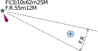 |
Main light visible all-round with red subsidiary light
seen over danger. The fixed red light has an elevation of 55 metres and
a nominal range of 12 nautical miles. The flashing light is white, with
three flashes in a period of 10 seconds. The elevation is higher than
the red light: 62 metres and the range of the white light is 25 nautical
miles. |
|
 |
Symbol showing direction of buoyage (where not obvious)
|
|
 |
Symbol showing direction of buoyage (where not obvious),
on multi-coloured charts (red and green circles coloured as
appropriate), here IALA A
|
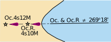
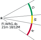
Full example of a light description in
the chart:

Fl(3)WRG.15s21m15-11M
Class of light: group flashing repeating a group of
three flashes;
Colours: white, red, green, exhibiting the different
colours in defined sectors;
Period: the time taken to exhibit one full sequence
of 3 flashes and eclipses: 15 seconds;
Elevation of light : 21 metres;
Nominal range(s): white 15 M, green 11 M, red
between 15 and 11 M, where “M” stands for nautical miles.
Lateral Marks - direction of buoyage
Lateral marks are generally for well-defined channels and there
are two international Buoyage Regions - A and B - where these Lateral marks
differ. Where in force, the IALA System applies to all fixed and floating marks
except landfall lights, leading lights and marks, sectored lights and major
floating lights.
The standard buoy shapes are cylindrical (can)
 , conical
 , spherical
 , pillar
 and spar
 , but variations may occur, for example: minor light-floats
 .
In the illustrations below, only the standard buoy shapes are used.
.
In the illustrations below, only the standard buoy shapes are used.
In the case of fixed beacons
 - lit or unlit - only the shape of the topmark is of navigational significance.
|
IALA
Region A
Europe
Africa
New Zealand
Australia
China
India
Russia
Indonesia
Turkey
Middle East
Etc. |
 |
|
|
IALA
Region B
Americas
Philippines
Japan
Korea
|
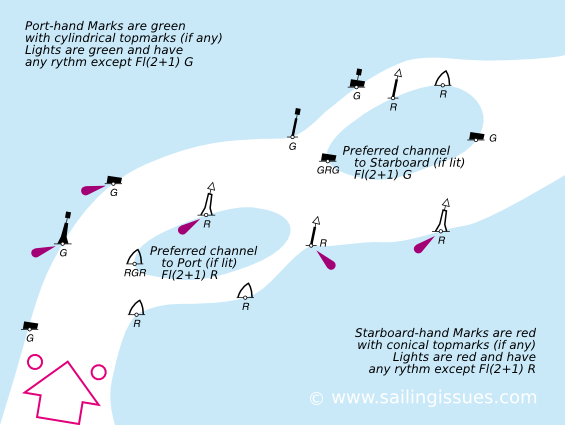 |
|
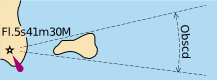
Visibility of lights
It is important to know at what distance we may (begin to) see a
certain light, and when we can expect to lose sight of it, especially when
making landfall. Several practical ranges are used to the describe the
visibility of lights in navigation:
|
Meteorological Optical Range Table |
|
Code No. |
Weather |
Distance (m) |
|
Code No. |
Weather |
Distance (nm) |
|
0 |
Dense fog |
Less than 50 |
5 |
Haze |
1.0 - 2.0 |
|
1 |
Thick fog |
50 - 200 |
6 |
Light haze |
2.0 - 5.5 |
|
2 |
Moderate |
200 - 500 |
7 |
Clear |
5.5 - 11.0 |
|
3 |
Light fog |
500 - 1000 |
8 |
Very clear |
11.0 - 27.0 |
|
4 |
Thin fog |
1000 - 2000 |
9 |
Exceptionally clear |
Over 27.0 |
-
The geographic range is based on
the elevation of the light. A higher light means that its horizon is farther
away, see
distance of horizon.
Moreover, if the observer's height of eye is higher than sea level the light
can been seen beyond its geographic range, the
dipping
range. However, on sailing yachts this potential is limited.
-
The nominal range of a light is
based on its candlepower, and is typically the range mentioned in the chart.
The nominal range is the maximum distance at which a light can be seen in
weather conditions where visibility is 10 nm.
So, a minor light - perched on a 70m high cliff - with a
geographic range of 20 nm will not be detectable by the human eye at a distance of 6 nm
-
if the nominal range is just 5 nm.
-
if the meteorological range is just 5 nm due to a light
haze.
Because of the limiting factor of the geographic range, most
major lights will never be seen from a sailing yacht 20 nm away. Yet, it is
sometimes possible to take a bearing on the loom of
the light: its reflection against the clouds.
Different coloured lights with equal candlepower have different
ranges. White light is the most visible followed by yellow, green and then red.
Therefore, at extreme ranges an “AL WG” can resemble a “Fl W”.
The range of a lit buoy is never indicated - with the exception
of a LANBY - but on a clear night the maximum range is 3 nm, yet often
considerably less.
There are 2 visual clues to determine your distance from a buoy: at about 0.5
nm, the light will rise up from the horizon, and at about 200m, the light will
reflect in the surface.
|
 |
|

|
|
Buoy at less than 3 nm
|
Buoy at less than 0.5 nm
|
Buoy at less than 200m
|
Glossary
-
Navigation aid: An onboard
instrument, device, chart, method, etc., intended to assist in the
navigation.
-
Aid to navigation: A device or
structure external to the ship, designed to assist in determination of
position, to define a safe course, or to warn of dangers or obstructions.
-
Mark, seamark,
navigation mark: An artificial or natural object of easily recognizable
shape or colour, or both, situated in such a position that it may be
identified on a chart. A fixed artificial navigation mark is often called a
Beacon.
-
Light characteristics: The
sequence and length of light and dark periods and the colour or colours by
which a navigational light is identified.
-
Topmark: One of more objects of
characteristic shape placed on top of a buoy or beacon to aid in its
identification.
-
Lateral Mark: An aid to
navigation intended to mark the sides of a channel or waterway.
-
Cardinal Marks: An IALA aid to
navigation intended to show the location of a danger to navigation based on
its position relative to the danger using the “cardinal point”: north, east,
south, west.
-
Isolated danger Marks: An IALA
aid to navigation marking a danger with clear water all around it; it has a
double ball topmark and is black with at least one red band. If lighted its
characteristic is Fl(2).
-
Sector light: A light having
sectors of different colours or the same colour in specific sectors
separated by dark sectors.
-
Light sector: As defined by
bearings from seaward, the sector in which a navigational light is visible
or in which it has a distinctive colour difference from that of adjoining
sectors, or in which it is obscured.
-
Lighthouse: A distinctive
structure exhibiting a major navigation light.
-
Light List: A publication giving
detailed information regarding lighted navigational aids and fog signals.
-
Landfall: The first sighting
(even by radar) of land when approached from seaward.
-
Range: Two or more objects in
line. Such objects are said to be in range. An observer having them in range
is said to be on the range. Two beacons are frequently located for the
specific purpose of forming a range to indicate a safe route or the
centerline of a channel.
-
Leading line: On a nautical
chart, a straight line, drawn through leading marks. A ship moving along
such line will clear certain dangers or remain in the best channel.
-
Range lights, leading
lights: Two or more lights at different elevations so situated to form a
range (leading line) when brought into transit. The one nearest to the
observer is the from light and the one farthest from the observer is the
rear light. The front light is at a lower elevation than the rear light.
-
Lights in line: Two or more
lights so situated that when observed in transit they define a position: the
limit of an area, an alignment used for anchoring, etc. Not to be confused
with range lights, which mark a direction to be followed.
-
Light-float : A buoy having a
boat-shaped body. Light-floats are nearly always unmanned and are used
instead of smaller lighted buoys in waters where strong currents are
experienced.
-
Primary (sea-coast) light: A
light established for purpose of making landfall or coastwise past from
headland to headland.
-
Secondary light: A major light,
other than a primary (sea-coast) light, established at harbour entrances and
other locations where high intensity and reliability are required.
-
Major light: A light of high
intensity and reliability exhibited from a fixed structure (lighthouse) or
on marine site (except range lights). Major lights include primary sea-coast
and secondary lights.
-
Minor light: An automatic
unmanned light on a fixed structure usually showing low to moderate
intensity. Minor lights are established in harbours, along channels, along
rivers, and in isolated dangers.
-
Visual range: The extreme
distance at which an object of light can be seen.
-
Geographic range: The extreme
distance limited by the curvature of the earth and both the heights of the
object and the observer.
-
Bobbing a light: Quickly
lowering the height of eye and raising it again when a navigational light is
first sighted to determine if the observer is at the geographic range of the
light.
-
Luminous range: The extreme
distance limited only by the intensity of the light, clearness of the
atmosphere and the sensitiveness of the observer's eye.
-
Luminous range diagram: A
diagram used to convert the nominal range of a light to its luminous range
under existing conditions.
-
Charted or Nominal Range: The
nominal range is indicated in the chart next to the light or can be found in
the Light List. This is the maximum distance at which a light may be seen at
night based upon intensity and 10 nautical miles of visibility.
-
Meteorological Range: The
nominal range is indicated in the chart next to the light or can be found in
the Light List. This is the maximum distance at which a light may be seen at
night based upon intensity and 10 nautical miles of visibility.