Meteorology
Forecast showers
An expedient guide to visually distinct between a fair weather
cumulus
and a rain bearing
cumulonimbus cloud, allowing you to forecast showers :
:
- A deepening (growing taller) cumulus signals showers. So, check whether
the distance from base to top larger is than the distance between the
earth's surface and the base.
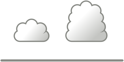
The right cloud spells rain, the left one is harmless.
- A solid, preferably top heavy cloud is much more likely to produce rain
than a chimney cloud. So, check whether the top is as wide as the base.
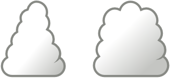
The right cloud spells rain, the left one is harmless.
- A
pileus (Latin: “cap”)
is an eyebrow shaped cap over the top of a developing rain cloud.
Eventually, the ascending cloud overtakes the icy pileus formations and
leaves these behind. In general: clouds that generate pilei are those most
likely to develop into full-blown cumulonimbus clouds.
Pileus
examples.
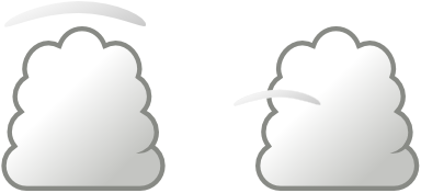
Both clouds bring rain.
Further insights
- It is easy to tell the difference between ice
and liquid in a cloud, because liquid has a very sharp cloud edge, yet
ice has a diffuse and fuzzy cloud edge.
- Virga is the meteorological term for rain,
snow or ice crystals visibly falling from a cloud in a streak, without
reaching the ground due to evaporation.
Virga
examples.
- A cloud that starts to rain will affect the wind
we sail in. Rain cools the air underneath the cloud through evaporation
as it collects heat (similar to perspiration), resulting in a downwash of
colder air. Expect gusts and a new wind direction which is a combination of
the original wind direction and the cloud's direction. A big cumulonimbus
will actually take over the local wind regime.
- Rain most often starts off as snow,
so an high rising cloud is necessary to reach the colder altitudes. Hence
the icy pilei and the height of the cumulus are good indications if showers
are imminent.